Atmosphere over the Pacific Ocean may be getting in gear for El Nino
By Climate CentralFriday, June 20, 2014 15:22 EDT
Originally published by Climate Central
The atmosphere over the Pacific Ocean may be getting its act together and finally cooperating with shifting ocean waters to signal that an El Niño has arrived, climate scientists with the National Oceanic and Atmospheric Administration reported in their latest outlook.
Animation of sea surface temperatures in the tropical Pacific Ocean.Credit: NOAA.
El Niño watchers have been waiting for the climate phenomenon to show up since anEl Niño Watch was issued back in March, meaning that conditions were favorable for one to develop in the next six months. Potential El Niño events are so closely watched because of the influence they can have on the world’s weather. Depending on when this El Niño develops, it could also bump up Earth’s already warming temperature enough to make 2014 or 2015 a record warm year, scientists have said.
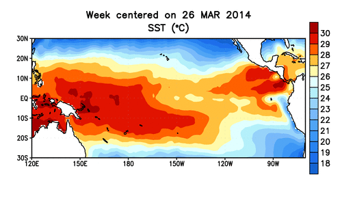
An El Niño is characterized by warmer-than-normal sea surface temperatures in the central and eastern tropical Pacific. It is the warm phase of a larger cyclical climate phenomenon called the El Niño-Southern Oscillation; La Niña is the cool phase and is characterized by colder-than-normal temperatures in the same parts of the Pacific.
But the phenomenon isn’t limited to the oceans; it also affects the wind patterns over those ocean waters. During an El Niño, the trade winds that normally blow from east to west across the tropical Pacific relax and reverse.
Sea surface temperatures have been hovering around the mark that determines an El Niño, which is defined as temperatures that are 0.5°C (0.9°F) above normal. Back in March, a large pulse of warm water called a Kelvin wave surged toward the eastern tropical Pacific from the western part. This happened because of the slackening of the trade winds, which normally pile that warm water up in the western part of the basin, but cause it to go tumbling to the east when they dissipate.
That Kelvin wave resulted in temperature anomalies that were comparable to those seen before the intense El Niño event of 1997-1998. But since then, temperatures have cooled somewhat, though they still indicate a developing El Niño, possibly just a more moderate one, climate scientists who monitor the phenomenon have said.
But as of the latest official forecast update from the Climate Prediction Center, issued on June 5, the atmospheric signals of an El Niño weren’t quite there, keeping forecasters from issuing an El Niño Advisory (which means El Niño conditions have been observed and are expected to continue). In particular, forecasters were waiting to see enhanced convection — the process that drives thunderstorms — over the area, as well as drier conditions over Indonesia, Michelle L’Heureux, a CPC meteorologist who helps put together the updates, told Climate Central at the time.
The latest update from Australia’s Bureau of Meteorology, issued on June 17, concurred with the CPC’s assessment.
In the last week or two, though, scientists have seen convection near the International Date Line in the tropical Pacific and have seen the trade winds behaving more like they should during a developing El Niño, Stephen Baxter, a seasonal forecaster with the CPC, told reporters during the Thursday briefing on the NOAA outlook.
“There is some indication that the atmosphere has become a little more responsive,” Baxter said.
Some other climate factors could be muddying the waters, L’Heureux told Climate Central in an email this week. A climate cycle called the Pacific Decadal Oscillation, which as its name suggests acts over decades, has been in a phase that tends to favor cooler conditions in the Pacific since the late 90s, just after the major 1997-1998 El Niño.
On the opposite time scale, a cycle called the Madden-Julian Oscillation acts over just a month or two and influences the trade winds. L’Heureux thinks the relative cooling over the past couple of weeks can be attributed to the MJO, which amps up the easterly winds, pushing away those warmer waters. But it’s possible the MJO could flip around in the next few weeks and set off a westerly wind burst, warming things up again.
“We’re in a ‘wait and let’s see’ mode,” L’Heureux said.
Even without that westerly wind burst, Baxter told reporters, there are indications that the Pacific is still headed for an El Niño.
“We’re nicely on track for a weak to moderate, but still potentially impactful” El Niño in the fall to winter months, he said.
Originally published by Climate Central