Kobe Bryant killed in S76 crash - Page 2 - PPRuNe Forums

26th Jan 2020, 21:41
Join Date: Apr 2014
Location: Wet Coast, Canuckland
Posts: 51
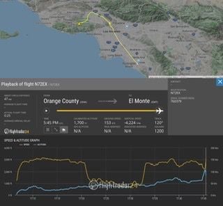
Last moments on FR24 data shows sharp increase in altitude with associated loss of airspeed. Possible flight towards rising terrain in low vis conditions and attempted emergency climb/turn/stall?


26th Jan 2020, 21:44
Join Date: Jun 2007
Location: Hamiltron, NZ
Posts: 26
Last ping on the FR24 track has the chopper with a ground speed of 153kts descending through 1700'.
Crash photo shows debris spread over a fair area. Impact with quite a bit of forward speed, perhaps? CFIT or mechanical?
Bloody sad.

26th Jan 2020, 22:07
Join Date: May 2007
Location: Alaska
Posts: 140
Are these aircraft equipped with EGPWS?
26th Jan 2020, 22:17
Join Date: Dec 2014
Location: Africa
Posts: 339
Quote:
Originally Posted by
Caboclo
Are these aircraft equipped with EGPWS?
It’s not an airliner.
26th Jan 2020, 22:20
Join Date: Jul 2001
Location: Nashville
Posts: 72
Quote:
Originally Posted by
Caboclo
Are these aircraft equipped with EGPWS?
Yes, EGPWS is standard equipment on the S-76D, as is a CVR and FDR.
26th Jan 2020, 22:22
Join Date: Feb 2008
Location: New York City
Posts: 311
Quote:
Originally Posted by
joema
Yes, EGPWS is standard equipment on the S-76D, as is a CVR and FDR.
This wasn't a -D, this was a S76B, from 1991.
Photos of the cockpit in old registration...avionics could have been updated:
https://www.helis.com/database/cn/51524/
26th Jan 2020, 22:23
Join Date: Dec 2000
Location: Arlington, Tx. US
Posts: 590
HaH
Many helicopters of that class have EGPWS.
26th Jan 2020, 22:27
Join Date: May 2016
Location: Philadelphia
Posts: 16
To anyone suggesting "sightseeing" as an explanation for the circles seen on the flight path, I think another possibility could be that they were put into a holding pattern by ATC waiting for traffic to clear. Might be a more probable explanation given the weather.
26th Jan 2020, 22:32
Join Date: Jun 2009
Location: VA, USA
Age: 54
Posts: 561
Witnesses on the ground reported the engines “spluttering” before the crash
26th Jan 2020, 22:39
Join Date: Jan 2009
Location: Sweden
Age: 52
Posts: 162
Quote:
Originally Posted by
hr2pilot
Last moments on FR24 data shows sharp increase in altitude with associated loss of airspeed.
You might want to check again which color that is what on FR24...
26th Jan 2020, 22:43
Join Date: Dec 2014
Location: Africa
Posts: 339
In a press briefing this morning the sheriff stated that 1 pilot plus all 8 pax have perished in this accident. Total 9 fatalities.
26th Jan 2020, 22:48
Join Date: May 2002
Location: Wanaka, NZ
Posts: 2,080
Last data points showing sink rate 5000 fpm and 160 kts GS, and erratic GS and VS just prior, that is not a helicopter being flown normally. Actually the data points don't make much sense at all.
26th Jan 2020, 22:56
Join Date: Feb 2008
Location: New York City
Posts: 311
ATC recordings have them requesting Special VFR after being told multiple en route areas are reporting IFR conditions
26th Jan 2020, 22:58
Join Date: Dec 2000
Location: uk
Posts: 1,620
Quote:
Originally Posted by
gulliBell
Last data points showing sink rate 5000 fpm and 160 kts GS, and erratic GS and VS just prior, that is not a helicopter being flown normally. Actually the data points don't make much sense at all.
FR24, unreliable with signals in a hilly area. I wouldn’t take too much from the info given. What it does show is an increase in speed right at the last moment and a decrease in altitude (dive?) but FR24 cant reliably be taken as real accurate Flight Data info.
If he had a net worth of half a billion dollars, its surprising he was flying around in such an old aircraft. I’d want latest tech and advanced nav/warning systems and maybe 2 crew? Who knows. Each to their own.
26th Jan 2020, 23:01
Join Date: Jan 2015
Location: Banksville
Posts: 35
How meaningful is request for special VFR?
26th Jan 2020, 23:08
Join Date: Sep 2011
Location: USA
Age: 50
Posts: 227
9 up in a B model. That's pushing range and CG.
26th Jan 2020, 23:12
Join Date: May 2002
Location: Wanaka, NZ
Posts: 2,080
It's meaningful because it suggests the weather was unsuitable for visual navigation, and the pilot needed to see where he was going to get to where he wanted to go. Which, I would think, is a more challenging option than changing flight category, turning around, and perform an instrument approach back where you've departed from.
26th Jan 2020, 23:22
Join Date: Jun 2008
Location: Ventura, California
Posts: 254
Liveatc Hold and request Special VFR through BUR and VNY
https://forums.liveatc.net/index.php...0;attach=10604
References to 5, 134, 118, 405, and 101 are Freeways.
101 runs from Van Nuys westward past crash site to Camarillo, the apparent destination.
Last edited by thcrozier; 26th Jan 2020 at 23:32 .
26th Jan 2020, 23:23
Join Date: Sep 2010
Location: SNA
Posts: 10
I live about 80 miles/130km SE from the crash site, but the terrain and microclimates are similar. I was mountain biking and there was a low-lying fog layer about 100-200 feet thick, with a broken around 3000-5000 feet (my estimate).
Another mountain biker and IFR-rated pilot was interviewed. He was first on the crash scene and said there was very dense fog with 3-4 feet of viz. They heard the S76 just before and during impact but did not see it. However, witnesses in the general area (I know those accounts turn out inaccurate) saw the helo "falter" and "sputter", and then steeply descend. So there seemed to be good visibility elsewhere.
The coastal scud in that area blows in from the west along Hwy 101 and hugs low-lying terrain. My very early speculation- they were VFR on top over a patchy ground fog layer in the canyon. A mechanical issue forced a descent into IFR and terrain.
26th Jan 2020, 23:24
Join Date: Dec 2013
Location: Dallas
Posts: 99
Quote:
Originally Posted by
gulliBell
Last data points showing sink rate 5000 fpm and 160 kts GS, and erratic GS and VS just prior, that is not a helicopter being flown normally. Actually the data points don't make much sense at all.
Proving, for the umpteenth time, that FR24 ground, altitude, and airspeed traces are not always reliable for interpreting the actions of an aircraft prior to a crash.