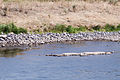
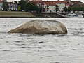
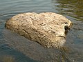
Stone that is normally covered by a body of water but exposed during periods of drought
Many of these stones, featuring carvings or other artwork, were erected following the hunger crisis of 1816–1817 caused by the eruptions of the Tambora volcano.[2]
| River
|
Location
|
Notes
|
Picture
|
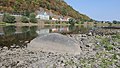
| Elbe
|
Děčín (Tetschen)
left riverbank, near the Tyrs bridge
50°46′57″N 14°12′28″E / 50.7825749°N 14.2078325°E / 50.7825749; 14.2078325 ( Hungerstein Decin )
|
The stone measures approximately 6 m³ and is carved with different years of drought. The oldest readable carving is from 1616, with older carvings (1417 and 1473) having been wiped out by anchoring ships during the years. The stone also features the Czech sentence „Neplač holka, nenaříkej, když je sucho, pole stříkej“ (lit. "Girl, don't weep and moan, if it's dry, water the field"), probably added in 1938.[5] This hunger stone is one of the oldest hydrological landmarks in the Elbe river.
|

|
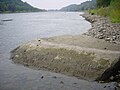
| Elbe
|
Tichlowitz near Děčín
|
Stone with the number 1666 (Roman: MDCLXVI)
|
|
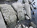
| Elbe
|
Tichlowitz near Děčín
50°42′20″N 14°11′50″E / 50.705692°N 14.197161°E / 50.705692; 14.197161 ( Hungerstein Techlovice )
|
Stone with multiple years: 1892, 1903, 1904, 1911, 1928, 1963, 2015 etc.
|
|
| Elbe
|
Dolní Žleb, part of Děčín
50°50′57″N 14°12′58″E / 50.849096°N 14.216029°E / 50.849096; 14.216029 ( Hungerstein Dolni Zleb )
|
Approximately ten stones with the years 1842, 1868, 1892, 1904, 2015[6]
|

|
| Elbe
|
Schmilka, near the border crossing[7]
|
|
|
| Elbe
|
Prossen, beneath former train conductor's house
|
Five years between 1928 and 2015 are carved on a skewed stone plate[7]
|
|
| Elbe
|
Königstein, near the village
|
Year 1681
|
|
| Elbe
|
Königstein, left riverbank near the Biela river
50°55′12″N 14°04′20″E / 50.919913°N 14.072226°E / 50.919913; 14.072226 ( Hungerstein Königstein )
|
Years 1952, 2003, 2015
|

|
| Elbe
|
Stadt Wehlen, district of Pötzscha
50°56′58″N 14°01′02″E / 50.949355°N 14.017302°E / 50.949355; 14.017302 ( Hungerstein Wehlen )
|
Year 1868[7]
|

|
| Elbe
|
Pirna, district Oberposta, right riverbank
|
According to the city archives, a stone with the year 1115 existed but its location is no longer known. Near Oberposta there is a stone with more than fifteen years between 1707 and 2015 carved into it
|
|
| Elbe
|
Dresden-Pillnitz, near the stairs of Pillnitz Castle's western sphinx
51°00′30″N 13°52′09″E / 51.008237°N 13.869039°E / 51.008237; 13.869039 ( Hungerstein Pillnitz )
|
Years: 1778, 1893, 1904, 2003, 2018.
|

|
| Elbe
|
Dresden-Laubegast
51°01′24″N 13°50′29″E / 51.023416°N 13.841373°E / 51.023416; 13.841373 ( Hungerstein Laubegast )
|
Years: 1893, 1899, 2003, 2015.
|
|
| Elbe
|
Dresden-Tolkewitz, near Tolkewitzer Street 73
51°02′31″N 13°49′04″E / 51.041975°N 13.817859°E / 51.041975; 13.817859 ( Hungerstein Tolkewitz )
|
Year: 2016.
|

|
| Elbe
|
Dresden-Blasewitz
|
2 by 2 meter stone near kilometer 48.7 with years: 1930, 1943, 1947, 1950, 1963 etc.
|
|
| Elbe
|
Radebeul-Kötzschenbroda, near the steam ship port
51°06′12″N 13°37′22″E / 51.103230°N 13.622900°E / 51.103230; 13.622900 ( Hungerstein Radebeul-Kötzschenbroda )
|
Year 1811[8]
|
|
| Elbe
|
Meißen
|
Was recorded by Johann Friedrich Usinus to have been spotted in 1746 bearing the carving of the year 1654[9]
|
| Elbe
|
Torgau, on the right side near the destroyed bridge
|
Can be seen at a water level of 50 cm or lower
|
|
| Elbe
|
Schönebeck (Elbe), near kilometer 311 on the right riverbank
|
Measuring 1,5 by 1,5 by 2 meters and weighing 10 tons
|
|
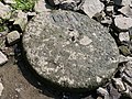
| Elbe
|
Schönebeck (Elbe), museum of the city (formerly in the port)
|
47 cm in size, year: 1904
|

|
| Elbe
|
Westerhüsen, part of Magdeburg
52°03′25″N 11°41′10″E / 52.056913°N 11.686170°E / 52.056913; 11.686170 ( Hungersteine bei Westerhüsen, Magdeburg )
|
see Hungerstones near Westerhülsen [de]
|

|
| Elbe
|
Magdeburg, Domfelsen
52°07′22″N 11°38′12″E / 52.12265°N 11.63668°E / 52.12265; 11.63668 ( Domfelsen, auch Hungerfelsen, Magdeburg )
|
Red sandstone formation near Domfelsen,also called Hungerfelsen (lit. "hunger cliff"); carved 2018 in August
|

|
| Elbe
|
Bleckede, near the ferry port
|
Kilometer 550. Carved with the sentence: Geht dieser Stein unter, wird das Leben wieder bunter (lit. When this stone sinks, life will become more colorful again) [10]
|
|
| Moselle
|
Traben-Trarbach-Litzig, left riverside
|
|
|
| Mündesee
|
Angermünde , north of the village
|
|
|
| Rhine
|
Worms-Rheindürkheim, near kilometer 449.4 on the left riverbank
|
Several stones, years ranging from 1857 to 2009
|

|
| Weser
|
Near Hajen, on the left riverbank
|
Red sandstone that was smoothed by the river
|
|
| Weser
|
Würgassen
|
3 m³ hunger stone with the years 1800, 1840, 1842, 1847, 1850, 1857, 1858, 1859, 1865, 1874, 1876, 1881, 1911, 1922, 1934 and 1959[11]
|
|
.JPG)
.JPG)
.JPG)
.JPG)
.JPG)

.JPG)
.JPG)
.JPG)
.JPG)


